domingo, 5 de novembro de 2023

Historic Centre (Old Town) of Tallinn | Estonia


* sent from Hong Kong


The origins of Tallinn date back to the 13th century, when a castle was built there by the crusading knights of the Teutonic Order. It developed as a major centre of the Hanseatic League, and its wealth is demonstrated by the opulence of the public buildings (the churches in particular) and the domestic architecture of the merchants' houses, which have survived to a remarkable degree despite the ravages of fire and war in the intervening centuries.

Year of Inscription: 1997

Fortress of Suomenlinna | Finland


Built in the second half of the 18th century by Sweden on a group of islands located at the entrance of Helsinki's harbour, this fortress is an especially interesting example of European military architecture of the time.

Year of Inscription: 1991

Works of Antoni Gaudí (Casa Batlló) | Spain


Seven properties built by the architect Antoni Gaudí (1852–1926) in or near Barcelona testify to Gaudí’s exceptional creative contribution to the development of architecture and building technology in the late 19th and early 20th centuries. These monuments represent an eclectic, as well as a very personal, style which was given free reign in the design of gardens, sculpture and all decorative arts, as well as architecture. The seven buildings are: Parque Güell; Palacio Güell; Casa Mila; Casa Vicens; Gaudí’s work on the Nativity façade and Crypt of La Sagrada Familia; Casa Batlló; Crypt in Colonia Güell.


Year of Inscription: 1984

Ancient and Primeval Beech Forests of the Carpathians and Other Regions of Europe | Ukraine


This transboundary property stretches over 12 countries. Since the end of the last Ice Age, European Beech spread from a few isolated refuge areas in the Alps, Carpathians, Dinarides, Mediterranean and Pyrenees over a short period of a few thousand years in a process that is still ongoing. The successful expansion across a whole continent is related to the tree’s adaptability and tolerance of different climatic, geographical and physical conditions.

Year of Inscription: 2007

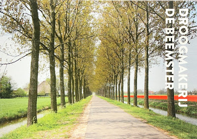
Droogmakerij de Beemster (Beemster Polder) | Netherlands


The Beemster Polder, dating from the early 17th century, is is an exceptional example of reclaimed land in the Netherlands. It has preserved intact its well-ordered landscape of fields, roads, canals, dykes and settlements, laid out in accordance with classical and Renaissance planning principles.

Year of Inscription: 1999

UNESCO WHS in the Czech Republic


* sent in an evelope

This postcard shows several Czech UNESCO WHSs, most of which are in my collection: 

  • Landscape for Breeding and Training of Ceremonial Carriage Horses at Kladruby nad Labem
  • Erzgebirge/Krušnohoří Mining Region
  • Historic Centre of Prague 
  • Litomyšl Castle
  • Kutná Hora: Historical Town Centre with the Church of St Barbara and the Cathedral of Our Lady at Sedlec
  • Pilgrimage Church of St John of Nepomuk at Zelená Hora
  • Holy Trinity Column in Olomouc
  • Historic Centre of Český Krumlov
  • Historic Centre of Telč
  • Tugendhat Villa in Brno
  • Gardens and Castle at Kroměříž
  • Holašovice Historical Village
  • Jewish Quarter and St Procopius' Basilica in Třebíč
  • Lednice-Valtice Cultural Landscape
  • Arles, Roman and Romanesque Monuments | France


    *sent in an envelope

    Arles is a good example of the adaptation of an ancient city to medieval European civilization. It has some impressive Roman monuments, of which the earliest – the arena, the Roman theatre and the cryptoporticus (subterranean galleries) – date back to the 1st century B.C. During the 4th century Arles experienced a second golden age, as attested by the baths of Constantine and the necropolis of Alyscamps. In the 11th and 12th centuries, Arles once again became one of the most attractive cities in the Mediterranean. Within the city walls, Saint-Trophime, with its cloister, is one of Provence's major Romanesque monuments.

    Year of Inscription: 1981

    domingo, 17 de setembro de 2023

    Pyrénées - Mont Perdu | France


    This outstanding mountain landscape, which spans the contemporary national borders of France and Spain, is centred around the peak of Mount Perdu, a calcareous massif that rises to 3,352 m. The site, with a total area of 30,639 ha, includes two of Europe's largest and deepest canyons on the Spanish side and three major cirque walls on the more abrupt northern slopes with France, classic presentations of these geological landforms. The site is also a pastoral landscape reflecting an agricultural way of life that was once widespread in the upland regions of Europe but now survives only in this part of the Pyrénées. Thus it provides exceptional insights into past European society through its landscape of villages, farms, fields, upland pastures and mountain roads.

    Year of Inscription: 1997


    domingo, 10 de setembro de 2023

    Historic Centre of Oporto, Luiz I Bridge and Monastery of Serra do Pilar | Portugal

    * sent from the Czech Republic


    The city of Oporto, built along the hillsides overlooking the mouth of the Douro river, is an outstanding urban landscape with a 2,000-year history. Its continuous growth, linked to the sea (the Romans gave it the name Portus, or port), can be seen in the many and varied monuments, from the cathedral with its Romanesque choir, to the neoclassical Stock Exchange and the typically Portuguese Manueline-style Church of Santa Clara.

    Year of Inscription: 1996

    High Coast / Kvarken Archipelago | Finland


    The Kvarken Archipelago (Finland) and the High Coast (Sweden) are situated in the Gulf of Bothnia, a northern extension of the Baltic Sea. The 5,600 islands of the Kvarken Archipelago feature unusual ridged washboard moraines, ‘De Geer moraines’, formed by the melting of the continental ice sheet, 10,000 to 24,000 years ago. The Archipelago is continuously rising from the sea in a process of rapid glacio-isostatic uplift, whereby the land, previously weighed down under the weight of a glacier, lifts at rates that are among the highest in the world. As a consequence islands appear and unite, peninsulas expand, and lakes evolve from bays and develop into marshes and peat fens. The High Coast has also been largely shaped by the combined processes of glaciation, glacial retreat and the emergence of new land from the sea. Since the last retreat of the ice from the High Coast 9,600 years ago, the uplift has been in the order of 285 m which is the highest known ''rebound''. The site affords outstanding opportunities for the understanding of the important processes that formed the glaciated and land uplift areas of the Earth''s surface.

    Year of Inscription: 2000

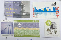
    Mill Network at Kinderdijk-Elshout | Netherlands


    The outstanding contribution made by the people of the Netherlands to the technology of handling water is admirably demonstrated by the installations in the Kinderdijk-Elshout area. Construction of hydraulic works for the drainage of land for agriculture and settlement began in the Middle Ages and have continued uninterruptedly to the present day. The site illustrates all the typical features associated with this technology – dykes, reservoirs, pumping stations, administrative buildings and a series of beautifully preserved windmills.

    Year of Inscription: 1997

    Vatnajökull National Park - Dynamic Nature of Fire and Ice | Iceland

    * sent from Germany This iconic volcanic region covers an area of over 1,400,000 ha, nearly 14% of Iceland's territory. It numbe...